Route surrounding the village of Ullastrell. It is a circular path, of approximately an hour and a half of duration, which shows the landscape of agricultural tradition of the village, rich in different types of fruit trees, which even today serve different markets of the region.
On this route they are linked two of the possible routes offered by the Vinya: the path of the Pont del Masover, in the southern area of the village, level of initiation, and the spring of Can Font, in the north, mid-level.
ROUTE
We leave the masia down the road, we cross it and just to the side of this, to the right,
we take the path that starts parallel to the road and that little by little is separating, getting into the crop fields.
Right away we will find a few small elm trees of little leaves, agaves, olive trees and a few large mastic shrubs on the right and a field of fig trees on the left. At the back we see Collserola. This path of soft and clay soils goes down slightly and the crop changes to vineyard and olive trees until we arrive to another path, surrounded by reeds: we take it to the right and it heads for a field of dry land that makes time that there is a lot of time since is left fallow. We follow the field margin, marked by a line of fennels, almond trees, olive trees and brambles. This is a good place to see rabbits, since in recent years, there has been an increase of the population of rabbits in the area. In the spring, in the afternoon, we will also be able to see some partridges.
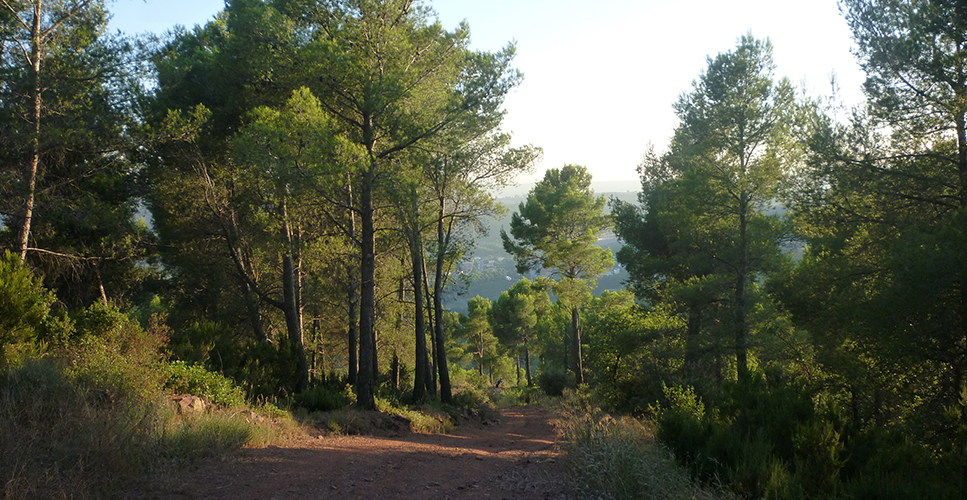
When we turn slightly to the right, the road changes of slope, the soil becomes drier and it is followed by many bushes of rosemary, redoul and a lot of thyme that smell when the horses graze them with their legs. We see how they grow some young pines and holm oaks, what shows that the time that the field has not been cultivated and the forest begins to invade it.
A little further, when there is a little bit of margin on the right, we will find a lot of oregano, among other wild plants which serve as attractive for different species of butterflies, which fly abundantly from March until the autumn. Above all we will be surrounded by the butterflies which lay down on the road, as the lasiommata megera, of orange and brown colour.
The path gets plainer and we will be able to see a series of persimmons (the tree that produces persimmons). Here we can see how the path becomes rockier, with pebbles, and the pine trees are gaining ground to the old crops. When passing by the side of the raft we will be able to see Montserrat and the masia of Can Pagès. We take the right and we will have the silhouette of Sant Llorenç at the back.
We surround the heliport and take the path to the left. Now we have the wider path again and we can distinguish the terraces, with almond trees at the right margin. Before entering the masia, that we have left raised just in front, we take the track that goes to the right, so that we follow the profile of the house which is on the left and on the right, hidden by a fence of hackberry trees, Mediterranean buckthorns and brambles, which indicate the greatest degree of humidity.
The path now goes down, width, under white pine, oak and many wild olive trees. To the right there are a couple of farms that are camouflaged by the vegetation. In the other ridge line, close to the village, we see many organized terraces, with olive trees. When we get to a sharp curve to the right, we continue toward here, despite the fact that the road also continues. We go down to the space of leisure “El Bolet”, plain and quite large, which takes advantage of the shade of the tall oaks, holm oaks and acacia trees that grow leafy by the humidity of the torrent. We follow the path, which is now heading for little by little, next to the clayey margin. To the left we see how the bank vegetation, of deciduous and larger and tender leaves, continues through the torrent, very different from the holm oaks, evergreen tree, with smaller and hard leaves, with grayish green colour, that better resist the dryness of the slope. Toward the end of the valley, we see how it widens and opens up to the river Llobregat.
We are following the way, plain again, with some spread houses around, surrounded by young pine and rosemary. When turning the curve we will see the village on the hill. We do a couple of more curves and cross another stream by a bridge. Right at the start of this, to the right, we see the cup of a walnut tree, a large laurel and a few oaks, all of them taking advantage of the humidity.
The road goes up smoothly, passing by a sector of very well cared olive, fig trees and vineyards on the left. We pass by the side of a kennel and there is a crossroads that if we would take it to the left it would lead us to the Vall del Llobregat (Castellbisbal) and to the right it returns us to the village of Ullastrell. We walk toward here and in the two sides we can see specimens of arbutus, holm oaks, some wild olive trees and vineyards and peach trees in the terrace below, as well as cherry trees on the left.
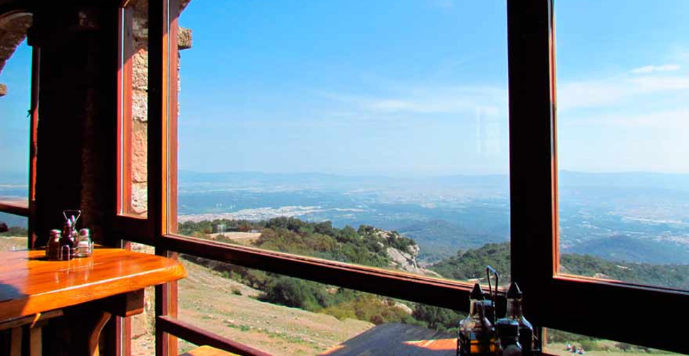
When the path turns to the north, we can see the road and to our left, a factory next to it, and, at the back, the town of Martorell, in the plain of the Llobregat. More to the left of the factory, below us, we can see a number of vegetable gardens and a grey spot: a plantation of eucalyptus. We move forward until we find the road, which we have to follow for a few meters in the direction of the village and cross it just under the cemetery. We pass by its side, leaving it to our left and straight on we find the way of the village, where we will see a curious view of Montserrat in diagonal. We enter the village and the first house that we see is an ancient masia restored, where the key of the cemetery is kept.
We continue straight on, passing through the streets of the village, which preserves a relaxed rural atmosphere despite being next to large cities. At the end of the street, we will see the Serralada Litoral again; we distinguish the Mola and the Serra de l’Obac and up to Montserrat perfectly. We turn to the left on a path that passes under the houses of the village and at the top we will see the bell tower, of pre-modernist style.
We follow the path indicated as “camí vell”, with good views of the largest cultivation of olive trees that there are in this hillside. In a crossroads that turns the way to the right, we continue straight on to go to the spring of Can Font, a cool and cozy place under large banana trees. Here we make a stop.
We go back for this last stretch up to the junction and we go down slightly until the ravine of Gaia, which we will take to the right by a detour. We will take advantage of the freshness of the water to climb part of the slope. Here we see how in addition to the holm oaks, there are the oaks and deciduous trees: black poplars, banana trees, maples and poplars, with many remains of vines hanging from the treetops. We will move between the margin and splashing the water until later we will take a wide track to the right signalled as Vallès Natural. Here it dominates the white pine. We will pass by the side of a poultry farm (we will hear the noise) and we will be gaining height slightly until the lands of Jaume Font, where we will end up the journey.
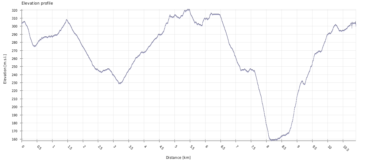
ACCUMULATE GRADE
DON’T MISS…

The Bolet: natural site located in the country house Can Palet, ideal to spend the day. There is a picnic area.
Santa Maria d’Ullastrell: parish church where it stands out the modernist bell tower (1908), the work of the architect from Terrassa Lluís Muncunill. For a good part of the medieval period, the parish of Santa Maria d’Ullastrell and its area, belonged to the monastery of Sant Llorenç del Munt.
Turó del Rector: closed garden with children’s playground located in the middle of the village, where we find a viewpoint with views to the mountains of Montserrat and Sant Llorenç.
The masies: the population of Ullastrell was structured in dispersed masies that focused their social activity in the parish church. The Marquis of Castellbell, lord of the municipality at the end of the 16th century, describes his property in the parish in a document where they appear the masies that have survived until our days, like Can Font or Can Palet, but also other already disappeared masies and of neighbouring villages, and which together formed the parish church of Santa Maria.
SUGGESTIONS
Sant Miquel de Toudell is a point of interest near this route.
Place
Ullastrell
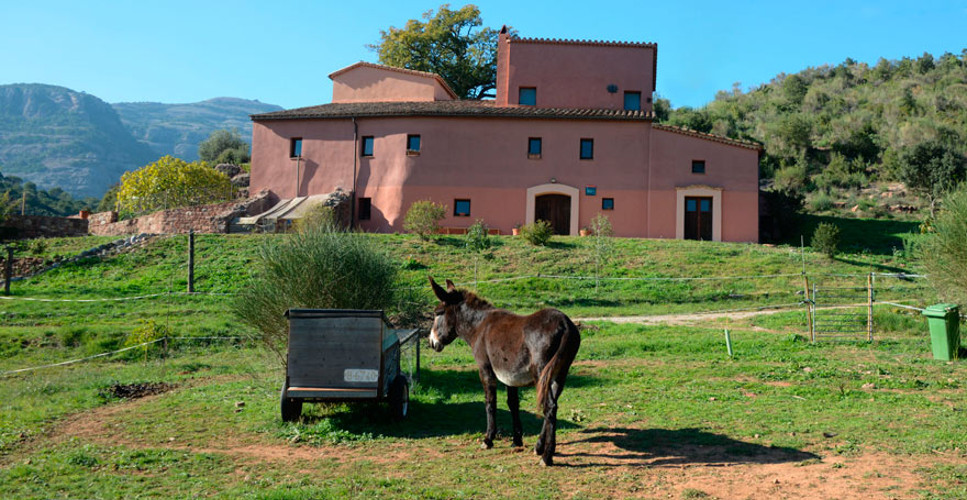
Where to start
Masia de Cal Jaume Font
Duration
2 h
Distance
10,9 km
Technical Difficulty
The route described joins the path of the Pont del Masover, level of initiation (low) with the path of the spring of Can Font, advanced level (medium difficulty).
Contact
Company: Center of equestrian activities The Vinya
Address: Masia Cal Jaume Font
Zip Code: 08231
Municipality: Ullastrell
Telephone: 649 937 168 304 351 961 /
WEB: www.hipicalaavinya4.wordpress.com
A/E: nornas3@hotmail.com
Price: To be consulted
Attendees: They have 8 horses for routes and school.
Score
[Total: 0 Average: 0/5]
Gallery

Share it


Send it to a friend


Download GPX route
![]()
Also you may be interested in…
Route of the Mirador
Discover the Vallès plain with this route around Sentmenat and Caldes de Montbui.
Visit our producers
Taste the unique flavours of the Vallès directly by the hand of their producers.
Unique restaurants
We have compiled a list of unique and high-quality restaurants in the Vallès. Will you miss them?
No Comments